LOCATION OF KERALA
IDUKKI DISTRICT IN KERALA
IDUKKI DISTRICT MAP
IDUKKI ROAD MAP
PERIYAR RIVER BASIN
RIVER DRAIN ITO ARABIAN SEA
MULLAPERIYAR DAM
The Mullaperiyar dam is a gravity dam which was built between 1887 and 1895 during the time of British rule in India. The dam was erected at the meeting point of two major rivers namely Periyar and Mullaiyar, thus obtaining the name Mullaperiyar. Mullaperiyar dam was constructed based on the lease agreement in 1886 between Travancore Princely State and British Presidency of Madras which allow to divert water of Mullaperiyar to British Presidency of Madras (Now Tamil Nadu). The agreement was for 999 years. But after independence entire agreement become lapsed. The agreement was resigned in 1970 between Kerala government and Tamilnadu.

 |
| MULLAPERIYAR DAM |
DESIGN
The Mullaperiyar Dam is a gravity dam made with limestone quicklime). Gravity dams use their weight and the force of gravity to support the reservoir and remain stable. The main dam has a maximum height of 53.6 m (176 ft) and length of 365.7 m (1,200 ft). Its crest is 3.6 m (12 ft) wide while the base has a width of 42.2 m (138 ft). It consists of a main dam, spillway on its left and an auxiliary dam (or "baby dam") to the right. Its reservoir can withhold 443,230,000 m3 (359,332 acre·ft) of water, of which 299,130,000 m3 (242,509 acre·ft) is active (live) storage
 |
| DURING CONSTRUCTION |
 |
| DURING CONSTRUCTION |
YELLOW LINE IS THE BOUNDARY BETWEEN KERALA AND TAMILNADU
The main reason for its construction by the British was to divert the abundance of the Periyar river water towards the state of Tamil Nadu. This decision was taken because Tamil Nadu was lacking enough water for its entire state and was depending on the Vaigai river which provides very less quantity of water for irrigation and drinking purposes
CONSTRUCTIION
The speciality of Mullaperiyar dam is that it is the only prevailing gravity dam in the world which is made of lime stone and surkhi, which is a mixture of sugar and calcium oxide

ISSUE
The interesting part about the Mullaperiyar dam is that though it is located within Kerala and is also completely owned by the state, the authority to operate the dam lies with the neighbouring state Tamil Nadu. This kind of agreement has eventually resulted in such a dilemma that one state has become totally dependant on the other’s decision for the safety of its own people. The government of Tamil Nadu is not giving the permission to Kerala for reducing the level of water in the dam as they fear that they will get less water in such a situation. The dam is almost 116 years old now and has reached a level where it cannot withstand too much water anymore
SEISMIC THREAT
The major concern is that the Mullaperiyar dam is situated on an earthquake prone zone and even a minor earthquake can result in the breakage of the dam. If such a disaster occurs, another alarming factor is that the water that would burst out from the dam will move towards the Idukki dam which could also break in case it cannot withstand all that water, the aftermath of which can be horrifying
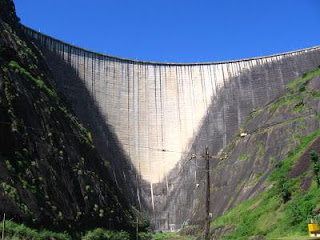
LOCATION IDUKKI DAM
Idukki Dam is the biggest arch-dam in Asia and the first in India. Main hydro-electric project of Kerala. It is 62km away from Thodupuzha and 75 km away from Kottayam. Construction of the dam started in 1969 and was completed in the year 1974.The Dam is built on the Periyar River, in the ravine between the Kuravan and Kurathi Hills in Kerala, India. At 167.68 meters, it is one of the highest arch dams in Asia. It started generating power on 4 October 1975 Technically, the dam type is a concrete double, curvature parabolic, thin arc dam.
This dam was constructed along with two other dams at Cheruthony and Kulamavu. Provision of gates is only for Cheruthony dam. Together, the three dams have created an artificial lake that covers 60 km² area. The stored water is used to produce electricity at the Moolamattom Power house, which is located inside nearby rocky caves. The Moolamattom power house is a CIDA (Canada India development Authority) project. The Government of Canada aided in the building of the dam with long term loans and grants
Kuravan & Kurathi Hills - Prior to the Idukki arch dam construction


Very Nice Information. Congratulations. You have taken immense efforts to gather so much information. I wish you will put in this web site a map of Periyar river showing all the 14 dams. Best wishes.
ReplyDelete